|
Outline |
|---|
|
The intermediate stage: propagation speed variation |
|---|
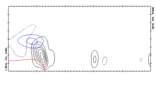
The animated GIF below incorporates both the early and intermediate stages, and part of the late stage as well. Note the SBF propagation speed variation, and the shape change of the frontal boundary as well, as the convection intensifies. (In the movie, the SBF is red and cloud contours are blue.) During the latter portion of the sequence, the SBF and HCR convection weakens substantially and the SBF propagation speed increases again.
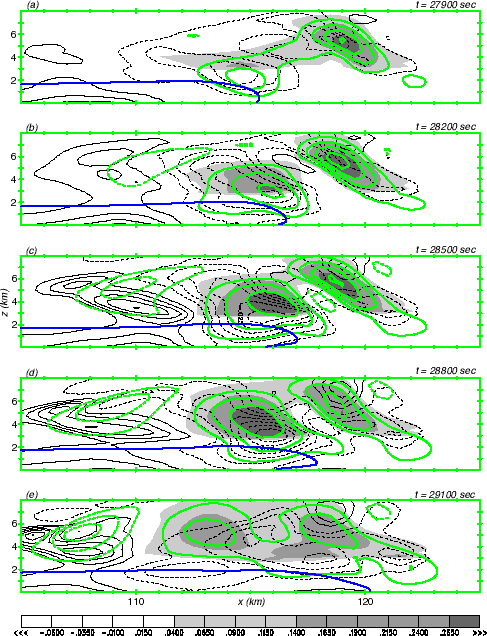
In the paper, a detailed analysis of the propagation variation is presented. A sketch of this is outlined here. First, we demonstrate the correlation between the propagation variation with latent heat release. In the figure below, the shaded field is condensation warming, the green contours indicate vertical motions. Note that the slowdown occurs right after dark shading appears above the SBF. The darker the shading, the more intense the heating.
The next figure presents a schematic illustrating the explanation. The top panel depicts the "background" situation that gets modified by latent heating. Cold, dense marine air is pushing inland. Behind the SBF, air is being accelerated towards the front, helping to keep it moving along. Above the SBF, warmer and less dense air that had originated over land is accelerated upward and seaward (to the left). This is the cold marine air pool's buoyancy-induced circulation. The arrow labeled "Fbx" represents the push of the horizontal component of this buoyancy circulation. Thus, marine air is being accelerated towards the SBF from behind.
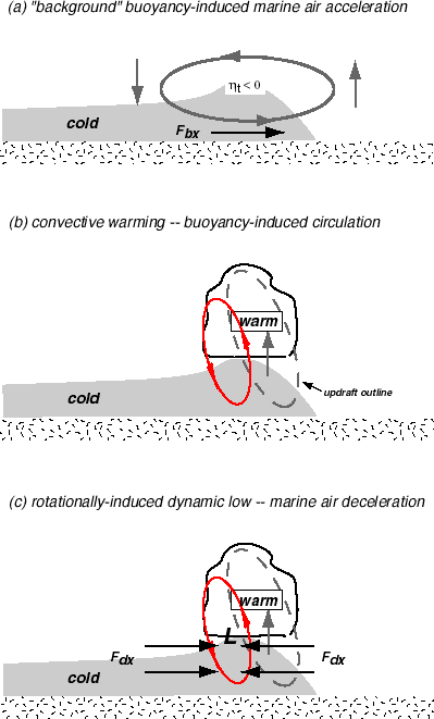
Clouds generate their own circulations, and these can combine with the cold pool circulation. As shown in the remaining panels, positive cloud buoyancy serves to drive upward (downward) motion inside (outside) the cloud. This circulation acts to make a rotational low pressure area on the cloud periphery; the dynamic low expected on the cloud's seaward side is depicted. In the marine air just behind the front, the horizontal forcing due to dynamic pressure ("Fdx") is acting oppositely to the buoyancy circulation. When the condensation heating is substantial, this opposing tendency is very strong, and the marine air behind the SBF can actually be slowed rather than accelerated as it approaches the front. During this time, SBF inland propagation slows (or even retreats seaward).
The animation linked here opens in a new window and focuses closely on the SBF boundary. The contours are DUDT, the parcel's total horizontal acceleration. Solid contours represent areas of inland (rightward) acceleration. As the SBF updraft reintensifies (and condensation heat release, not shown, is very strong), DUDT behind and beneath the marine air boundary becomes negative (indicating deceleration). The SBF starts slowing right after this happens, and continues to slow until positive DUDT reappears in this area. That happens after the convection subsides. (Note especially the "leaping" ahead of the SBF that follows reappearance of positive DUDT at the front.)
Page created February, 2000, by
 Robert Fovell