|
The early stage |
|---|
The figure below spans the early stage. This figure depicts fields that have been averaged along the coastline (which actually resides at x = 45 km, well beyond the left edge of the subdomain displayed.) Vertical velocity is shown (dashed contours represent descent), along with cloud water contours (in red) and the cool marine air boundary (in blue). The leading edge of the latter is the SBF.
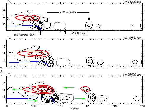
The SBF is pushing inland at about 15 km/h (9 mph) at this time. There is an updraft at its leading edge which sports a shallow cloud above it. In the top panel, the SBF is in the act of assimilating a very weak roll updraft. The HCR located above x = 120 km is strengthening during this period, and by the time of the bottom panel has a shallow cap cloud above it. The green arrows mark the horizontal flow; the HCR leans towards the oncoming SBF as it grows vertically. In between the SBF and this HCR is a weak roll downdraft.
|
The intermediate stage |
|---|
The figure below depicts the first segment of the intermediate stage which encompasses the most dramatic SBF-HCR encounter. Note the roll located above x = 120 continues to intensify, spawning a deep and strong convective cloud above it. Note also that as the SBF approaches this strengthening roll, its own cloud is suppressed. The circulation associated with the roll updraft, its cloud, and the downdraft that had appeared in between, combined to push less favorable dry midtropospheric air into airstream that was flowing above the SBF, and this choked off the SBF cloud. By the last time shown, there is virtually no cloud remaining right above the SBF.
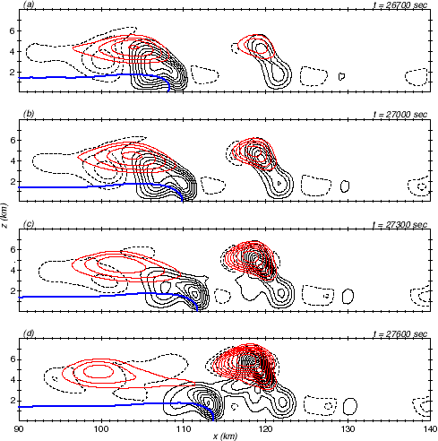
The second segment of the intermediate phase is shown below. As the SBF continues to close in on the ever-growing roll, several interesting things happen. First, the SBF propagation speed increases. With the absence of condensation warming above the front, the pressure difference across the front increases, leading to faster movement. Second, the frontal updraft strengthens, a logical consequence of the faster propagation. This updraft intensification leads to the regeneration of convection directly above the front, and this convection is now deep and strong rather than shallow. By the time of the bottom panel there are two strong updrafts -- separately spawned by the SBF and HCR -- hidden within a single cloud shield.
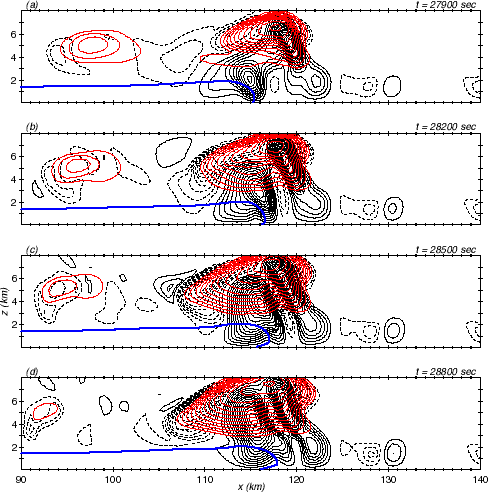
The regenerated convection is so strong, releasing so much condensation warming, that the SBF propagation speed slows dramatically around this time. Indeed, the frontal boundary in contact with the surface actually retrogrades during the last few time periods depicted in the figure. On the next page, this time period is animated to better present the convective development and propagation speed variations.
On to page 2
Page created February, 2000, by
 Robert Fovell
i
Robert Fovell
i