Numerical simulation of the interaction between the
sea-breeze
front and horizontal convective rolls.
Part I: Offshore ambient flow
Peter S. Dailey and Robert G. Fovell
Monthly Weather
Review
May, 1999 (vol 127, p. 858)
This page presents a brief overview of the paper that can be understood (hopefully!) by an individual with a basic background in meteorology. Only a portion of the paper's content is covered below. Please direct comments, questions, and/or reprint requests to Robert Fovell.
Links to sections on this page:
The sea-breeze circulation is driven by daytime heating contrasts between land and water surfaces. During the day, cool marine air is drawn inland as the land surface is heated by the sun. Convergence at the sea-breeze front (SBF), the leading edge of the marine air, occurs as the denser marine air underruns the warm air residing over the land. The warm air is lifted, and this can cause a band of clouds to form along the frontal boundary that may help initiate afternoon thunderstorms.
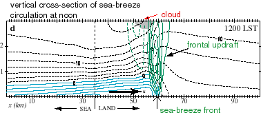
The figure below shows horizontal and vertical velocity fields at noon from a two-dimensional (2D) simulation using a high-resolution numerical "cloud model". The model was initialized with environmental conditions typical of Florida in August at sunrise. The coastline is located at x=35, with sea on the left. During the simulation, the land surface is heated by solar radiation. The horizontal velocity contours shown in blue represent the marine air pushing inland. The green contours depict the vertical velocity field; note the frontal updraft at the leading edge of the marine air. A cloud (albeit a minor one) has been formed above the SBF, near the top of the region plotted.
The figure linked here shows how the sea-breeze developed over the middle to late morning, starting at 9AM. (Hit your browser's back button after viewing this figure.) Here is a brief description of that figure's panels :
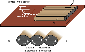
As the SBF propagates inland, it may encounter horizontal convective rolls (HCRs) that have formed in the lower atmosphere over the land surface. These rolls are tube-like vortex couplets forced by surface heating. They develop in the presence of vertical wind shear and tend to align themselves with the mean wind. The schematic diagram below describes the structure of the HCRs. Note that clockwise and counterclockwise circulations alternate. Between the rolls, either upward or downward motion is forced, depending on the location. Air lifted by the roll updrafts can saturate, forming a neat arrangement of "cloud streets" aligned along the rolls.
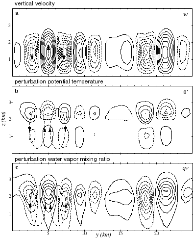
HCRs act to mix up the lower part of the atmosphere, called the boundary layer. The figure linked here shows vertical cross-sections across a set of HCRs as simulated in a three-dimensional numerical model. As before, the model was initialized at sunrise using Florida August conditions. The rolls were excited by superposing small, random perturbations on the model's surface heat flux. The model domain is entirely over land, so no sea-breeze forms. A brief description of the panels:
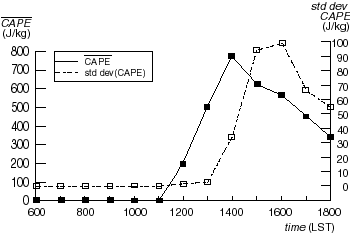
The degree of roll activity is revealed by the dashed sequence (white boxes), which measures the variability in CAPE across the rolls. The rolls appear shortly after 1PM local time (1300 LST), and the variations in moisture and temperature between the roll updraft and downdraft areas combine to cause differences in instability. Rolls mix the lower atmosphere vertically, and the CAPE starts declining after 2PM (1400 LST) as the roll-induced mixing churns up the lower atmosphere. Eventually, roll activity subsides as the sun gets lower in the sky, decreasing surface heating.
Both the SBF and HCRs produce lifting, which can lead to deep convective thunderstorms under the proper conditions. In the two simulations shown above, however, neither the SBF nor the HCRs were strong enough to cause the development of deep clouds.
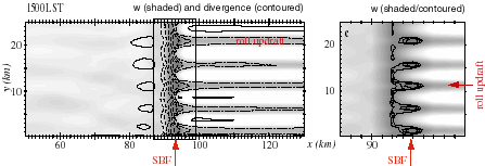
Yet another 3D simulation was made, this time including both HCRs and a sea surface in order to examine how the SBF and HCRs interact. In this case, the mean horizontal wind was directed offshore, perpendicular to the coastline. As a result, the HCRs formed over land oriented perpendicular to the approaching SBF. Before the appearance of rolls, and after their disappearance, the SBF is a nearly 2D entity stretched along the coastline. However, during the middle afternoon, when the HCRs are strong, concentrated areas of particularly strong lifting appear along the SBF where the front has intersected with a roll updraft.
The combination of SBF and HCR lifting in this case is sufficient to trigger deep, if short-lived, convection, something neither phenonemon was capable of doing independently. The figure below shows a wire-frame diagram of the cloud field at 2:20PM (1420 LST). Only the two strongest rolls possess shallow roll clouds, but the SBF has discrete shallow frontal cumuli at all five roll updraft intersection points. The time shown is just before one of the frontal clouds grows into a deep thunderstorm.
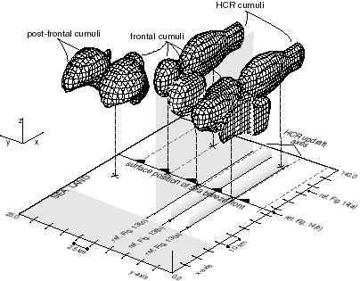
It is clear that enhanced SBF cloudiness occurred where the HCR updraft intersected the front. There can be at least two convolved reasons for this: (1) the extra lifting provided by the HCR updraft itself; and (2) the enhanced convective instability in the air within the roll updrafts. Recall that the roll circulations caused variations in CAPE across the rolls, principally because the roll updrafts lifted moisture from the lowest-levels. This made the air traveling along the roll updrafts "juicier" and more prone to convective instability, leading to enhanced frontal cumuli at the roll updraft intersection locales.
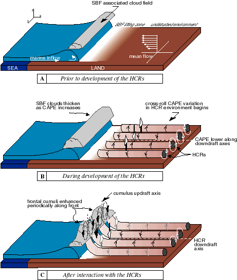
Especially striking to us is the absence of cloudiness at the downdraft intersection points. The spatial variability of lifting and cloudiness along the sea-breeze front appears to be as much due to the influence of roll downdraft suppression as roll updraft enhancement. This could have occurred because of local circulations established by the enhanced frontal cumuli. Once they develop, the frontal cumuli will establish subsidence on their flanks, and this coincides with the roll downdraft intersection points. Thus, there seems to be a positive convective feedback owing to cloud-scale circulations that maintains the along-frontal variability once that variability has been established. This occurs as long as the rolls are strong enough to create that variability. The figure below presents a schematic representation of the foregoing discussion.
Page created May, 1998, by
 Robert Fovell